Home
Schedule Demonstration
Services
  • Digital Twins
  • Drone Services
  • 3D Facility tour
  • Immersive Studios
Solutions
  • Kronoteq for DOT's
  • Kronoteq for Railroads
  • Kronoteq ROI
  • Solutions
AMP5D
  • Samuel
Home
Schedule Demonstration
Services
  • Digital Twins
  • Drone Services
  • 3D Facility tour
  • Immersive Studios
Solutions
  • Kronoteq for DOT's
  • Kronoteq for Railroads
  • Kronoteq ROI
  • Solutions
AMP5D
  • Samuel
More
  • Home
  • Schedule Demonstration
  • Services
    • Digital Twins
    • Drone Services
    • 3D Facility tour
    • Immersive Studios
  • Solutions
    • Kronoteq for DOT's
    • Kronoteq for Railroads
    • Kronoteq ROI
    • Solutions
  • AMP5D
    • Samuel
  • Sign In
  • Create Account

  • Bookings
  • My Account
  • Signed in as:

  • filler@godaddy.com


  • Bookings
  • My Account
  • Sign out


Signed in as:

filler@godaddy.com

  • Home
  • Schedule Demonstration
  • Services
    • Digital Twins
    • Drone Services
    • 3D Facility tour
    • Immersive Studios
  • Solutions
    • Kronoteq for DOT's
    • Kronoteq for Railroads
    • Kronoteq ROI
    • Solutions
  • AMP5D
    • Samuel

Account


  • Bookings
  • My Account
  • Sign out


  • Sign In
  • Bookings
  • My Account

KRONOTEQ DRONE SERVICES

Agricultural

Residential Real Estate

Residential Real Estate

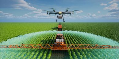
Drones are revolutionizing agriculture by providing farmers with powerful tools to monitor crops, assess soil health, and optimize yields. Key services include:


  • Crop Monitoring: Drones equipped with multispectral sensors can detect crop health issues early, allowing for timely intervention.
  • Precision Agriculture: Drones can create detailed maps for variable rate application of fertilizers and pesticides, reducing waste and improving crop yields.
  • Field Surveying: High-resolution aerial imagery helps in mapping fields, assessing plant health, and planning irrigation systems

Residential Real Estate

Residential Real Estate

Residential Real Estate

Drones offer a unique perspective for showcasing residential properties, making listings more attractive to potential buyers. Services include:


  • Aerial Photography and Videography: High-quality images and videos highlight property features and surroundings.
  • 3D Virtual Tours: Drones can create immersive virtual tours, giving buyers a realistic view of the property.
  • Marketing Videos: Professionally edited videos can enhance online listings and social media promotions.

Commercial Real Estate

Residential Real Estate

Commercial Real Estate

 For commercial properties, drones provide valuable insights and marketing advantages. Services include:


  • Property Showcasing: Aerial footage showcases the property’s location, size, and proximity to amenities.
  • Inspection and Maintenance: Drones can inspect roofs, facades, and other hard-to-reach areas, ensuring the property is well-maintained.
  • Construction Monitoring: Regular drone flights can document construction progress, providing stakeholders with up-to-date visuals.
  • Marketing Videos: Drone Videos can help you create a strong brand and develop effective marketing strategies to reach your target audience. We'll help you create engaging content and leverage social media to grow your business.

Industrial

Telecommunications

Commercial Real Estate


In industrial settings, drones enhance safety and efficiency. Key services include:


  • Inspections: Drones can inspect infrastructure such as pipelines, power lines, and wind turbines, reducing the need for manual inspections.
  • Surveying and Mapping: High-resolution imagery and 3D mapping help in planning and monitoring industrial sites.
  • Thermal Imaging: Drones equipped with thermal cameras can detect heat leaks, electrical issues, and other problems

Telecommunications

Telecommunications

Telecommunications


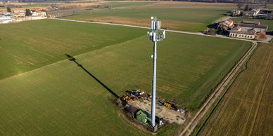
Drones are becoming essential in the telecommunications industry for their ability to quickly and safely inspect and maintain infrastructure. Key services include:


  • Tower Inspections: Drones can inspect cell towers, antennas, and other equipment, identifying issues without the need for climbing.
  • Network Planning: High-resolution aerial imagery helps in planning the placement of new towers and optimizing network coverage.
  • Emergency Response: In the event of natural disasters, drones can quickly assess damage to telecommunications infrastructure and assist in restoration efforts.

Utility Services

Telecommunications

Telecommunications


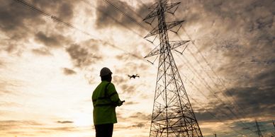
In the utility sector, drones enhance the efficiency and safety of operations. Key services include:


  • Power Line Inspections: Drones can inspect power lines and poles, identifying potential issues such as vegetation encroachment or structural damage.
  • Pipeline Monitoring: Drones equipped with thermal cameras can detect leaks and monitor the condition of pipelines.
  • Solar Panel Inspections: Drones can inspect large solar farms, identifying faulty panels and ensuring optimal performance.

We're Hiring Pilots!

Join the Kronoteq Flight Team

If you're interested in one of our open positions, start by applying here and attaching your resume.

Apply Now

Attach Resume
Attachments (0)

This site is protected by reCAPTCHA and the Google Privacy Policy and Terms of Service apply.

Copyright © 2025 KronoTeq - All Rights Reserved.

Powered by

  • Samuel

Sign up for Online or In-Facility Demonstration

  • ROI Calculator
  • Kronoteq for Railroads
  • Kronoteq for DOT's
  • Preventative Maintenance analysis
  • SOP Creation
  • CMMS - Computerized maintenance management system 
  • 3D Facility tour / management
  • Drone services
  • Vibration analysis
  • Blueprint digitization and organization

Learn more

This website uses cookies.

We use cookies to analyze website traffic and optimize your website experience. By accepting our use of cookies, your data will be aggregated with all other user data.

DeclineAccept